


Western Alaska Minerals’ New District-Scale CRD-Porphyry Exploration Modeling Reveals High-Potential Targets for 2023 Drilling
TUCSON, AZ / ACCESSWIRE / February 28, 2023 / Western Alaska Minerals Corp. (the “Company” or “WAM”) (TSXV:WAM) is pleased to announce updated interpretations of geological, geochemical, and geophysical surveys, which combined, indicate multiple high-potential carbonate replacement deposit (“CRD”) and porphyry copper-gold drill targets on the 100%-owned Illinois Creek property in Alaska, USA.
Highlights
“East Block” (see Map 1)
- Geophysics (IP and CSAMT) and soil geochemistry reveal several robust overlapping anomalies that coincide closely with the high-grade silver-lead-zinc CRD mineralization discovered in 2022 (See Press Releases of Sep 22, 2022 and Jan 17, 2023).
- IP geophysics indicates an offset of the Waterpump Creek CRD mineralization but continuing 1.4 kms to the south across the Illinois fault (See Figure 3 below). This look-alike anomaly is over three times longer than the current known Waterpump Creek sulfide body. The anomaly continues to the limits of the IP survey.
“West Block” (see Map 1)
- Several large-scale new targets have been developed, including an approximately 4 x 2 km target dubbed the “Warm Springs” CRD target. This target is in untested carbonate stratigraphy permissive for mineralization adjacent to historically mined Au/Ag gossans.
- The Warm Springs CRD target extends to the west into a major coincident copper-gold soil anomaly lying south of the historical Illinois Creek gold oxide mine. This 1.5 x 1.5 km target could represent the porphyry-related mineralizing fluid source for the property.
“Our rapidly growing data sets have defined some very exciting targets for our upcoming program,” said Kit Marrs, Western Alaska’s President and CEO. “I would like to acknowledge our technical team for their excellence in compiling and reinterpreting our historical and new data. We are eager to get back on the ground and get the rigs turning”.
Execution Plans
The Company is having additional drilling rigs built for fast-track testing of the numerous targets emerging from the updated exploration model. Current plans are to drill up to 17,000m in 2023, deploying up to 4 rigs to both expand the Waterpump Creek mineralization discovered in 2022 and begin testing the property wide CRD exploration targets.
A modern 3D IP/resistivity geophysical survey is planned to: 1) Confirm and improve resolution of the reinterpreted Waterpump Creek/Last Hurrah sulfide anomaly; and 2) Define additional anomalies over a 3 x 6 km area of the East Block north and south of the Waterpump Creek discovery.
A district-wide helicopter-borne geophysical survey to further the understanding of the geologic framework of the East and West Blocks, and to define additional targets including copper-gold porphyry/skarn deposits is also being planned.
Click here to watch the technical summary video.
Technical Background for 2023 Exploration Program
The regional geologic model has greatly improved over the past few months through integration of historical and new geophysics, geochemistry, and geology from drilling. The updated and improved components for the new exploration targeting model include:
- An interpretive property-wide geologic map;
- Further evidence that identified geochemical anomalies show direct correlation with mineralization;
- CSAMT geophysical survey profiles and lithology from recent and historical drilling provide for a new geologic framework including several faults believed to have controlled CRD mineralizing fluid migration;
- Reprocessed Induced Polarization (IP)/resistivity geophysical survey results, including 3D inversion modeling and detailed geophysical parameter measurements on drill core; and
- Modeling of the Waterpump Creek high grade silver-lead-zinc sulfide body.
Importantly, the new geologic interpretation shows the East Block and the West Block, two different lithostratigraphic/structural blocks, separated by “Wade’s” fault. Each shows distinct geological frameworks and unique exploration targets of significant scope.
The targeting map, Map 1, is derived from historical and 2022 soil geochemistry, drill intercepts, and geophysics briefly described below. For a detailed technical discussion, click here to view our Exploration Update.
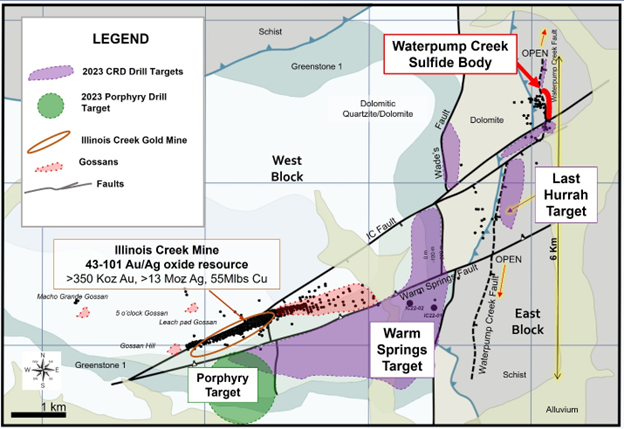
Map 1. 2023 District Target Map showing the East and West Blocks on either side of Wade’s fault.
Soil Geochemistry
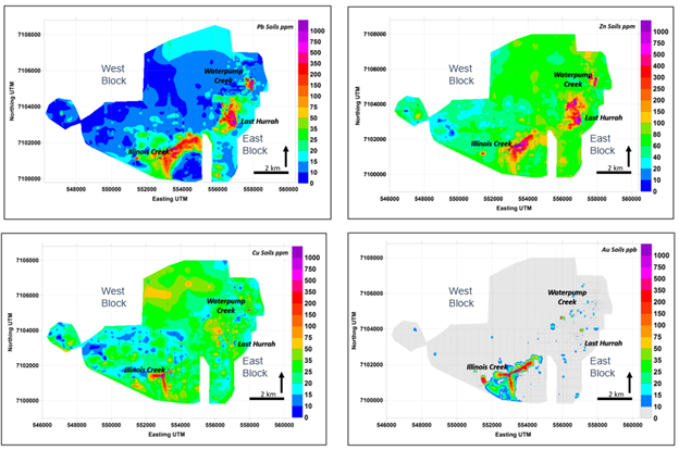
Figure 1. Selected Soil Geochemistry maps for lead, zinc, copper, and gold.
In the East Block, major lead-zinc anomalies occur in dolomites, reflecting leakage from the Waterpump Creek feeder structure. A major soil anomaly at the Last Hurrah target continues for another 2 kilometers and may reflect the presence of the Waterpump feeder fault downdip.
In the West Block, major lead and zinc anomalies reflect where the mineralized permissive carbonate stratigraphy comes to surface between the Illinois Creek fault and the Warm Springs fault. These anomalies reflect the Illinois Creek oxide gold-silver deposit. South of the Illinois Creek pit and the Warm Springs fault, an extensive (1.5 x 1.5 km) newly recognized copper, gold, lead, zinc soil anomaly continues to the south along an apparent NNW to NNE-trend. This anomaly with its copper and gold signature could suggest leakage from a possible porphyry center at depth.
Waterpump Creek Sulfide Body
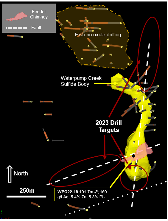
Figure 2. Waterpump Creek sulfide body and 2022 drill pierce points.
In Figure 2, drill intercepts from 2021-2022 define the 3D shape (yellow) of the Waterpump Creek sulfide body. Red circles show 2023 target areas to be drilled to extend known sulfide mineralization. The historical oxide body outline is shown to the north.
Geophysics
The 2005 IP/Resistivity geophysical data were reprocessed and reinterpreted by the Company’s recently hired geophysicist contractor, Brock Bolin, with key results shown in Figure 3 below. The 3D inversion modeling shows that a strong conductivity anomaly coincides closely with the Waterpump Creek sulfide body. The anomaly continues to the Illinois Creek fault, where it is offset to the west. From there it is continuous and increases in apparent volume for over 1.4 km to the southern limit of the survey. The highly prospective Last Hurrah target (Map 1) is based on a combination of the geometry of the known CRD mineralization (Fig. 2), coincident soil geochemistry anomalies (Fig. 1), and the conductivity anomaly results shown in Figure 3.
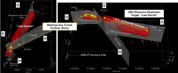
Figure 3. Two views of the untested Last Hurrah target (in red) showing offset from the Waterpump Creek sulfide body (in yellow). The grey surfaces are the extensions of the Waterpump Creek fault and the offsetting Illinois Creek fault. Fault plane locations are approximate.
Qualified Person
Stuart Morris, P. Geo., is the qualified person as defined under National Instrument 43-101 that reviewed and approved the technical disclosures in this release. Mr. Morris is an independent consultant, Registered Geologist with the British Columbia Association of Professional Engineers and Geoscientists (BC-APEG) No. 135066 and with the Arizona State Board of Technical Registration No. 16289. Mr. Morris has a MS in Economic Geology and 40 plus years of experience in mineral resources, mine, and exploration.
His review verified the data disclosed, including geology, sampling, analytical and QA/QC data underlying the technical information in this news release, including reviewing the reports of ALS, methodologies, results, and all procedures undertaken for quality assurance and quality control in a manner consistent with industry practice.
About WAM
WAM is an Alaska and Arizona based company, listed on the TSX-V and focused on discovery of high-grade, district-scale ore systems in the historic Illinois Creek Mining District located in western Alaska. WAM’s 100% owned claims cover 73,120 acres (114.25 square miles or 29,591 hectares), roughly 45 km from the Yukon River. The District encompasses at least five deposits containing gold, silver, copper, lead, and zinc and was originally discovered by Anaconda Minerals Co. in the early 1980’s. Since 2010, WAM, along with precursor Western Alaska Copper & Gold Company, has reassembled the Anaconda property package and been engaged in exploring the District.
On behalf of WAM
“Kit Marrs”
Kit Marrs
President & CEO Phone: (520) 200-1667
For further information please contact:
Vanessa Bogaert, Director of Corporate Communications/IR at [email protected]
Or visit our website at:www.westernalaskaminerals.com
Forward Looking Information
Certain statements made, and information contained herein may constitute “forward looking information” and “forward looking statements” within the meaning of applicable Canadian and United States securities legislation. These statements and information are based on facts currently available to the Company and there is no assurance that actual results will meet management’s expectations. Forward-looking statements and information may be identified by such terms as “anticipates”, “believes”, “targets”, “estimates”, “plans”, “expects”, “may”, “will”, “could” or “would”. Forward-looking statements and information contained herein are based on certain factors and assumptions regarding, among other things, the estimation of mineral resources and reserves, the realization of resource and reserve estimates, metal prices, taxation, the estimation, timing and amount of future exploration and development, capital and operating costs, the availability of financing, the receipt of regulatory approvals, environmental risks, title disputes and other matters. While the Company considers its assumptions to be reasonable as of the date hereof, forward-looking statements and information are not guaranteeing of future performance and readers should not place undue importance on such statements as actual events and results may differ materially from those described herein. The Company does not undertake to update any forward-looking statements or information except as may be required by applicable securities laws.
Neither TSX Venture Exchange nor its Regulation Services Provider (as that term is defined in the policies of the TSX Venture Exchange) accepts responsibility for the adequacy or accuracy of this release.
SOURCE: Western Alaska Minerals Corp.
View source version on accesswire.com:
https://www.accesswire.com/741079/Western-Alaska-Minerals-New-District-Scale-CRD-Porphyry-Exploration-Modeling-Reveals-High-Potential-Targets-for-2023-Drilling