

Altamira Gold Expands Mineralized Porphyry System at Maria Bonita Gold Deposit, Cajueiro District, Brazil
Vancouver, British Columbia–(Newsfile Corp. – July 23, 2026) – Altamira Gold Corp. (TSXV: ALTA) (FSE: T6UP) (OTCQB: EQTRF), (“Altamira” or the “Company“) is pleased to report assay results from additional exploration drilling immediately to the north-west of the existing Maria Bonita gold deposit.
Highlights:
- Two drill holes completed to the north-west and outside of the Maria Bonita gold resource have intersected wide zones of mineralized and altered rocks in both porphyry intrusive and adjacent volcanic tuff wall rocks.
- Drill hole MBA039 intersected 117m @ 0.4g/t gold from surface in predominantly volcanic tuffs. Drill hole MBA038 returned 74m @ 0.3g/t gold from 74m downhole associated with hydrothermal quartz veining, hosted in both porphyry and adjacent volcanic tuff wall rock.
- Both intercepts lie outside the current mineral resource and confirm potential to extend the mineral resource to the north, west and at depth.
- The volcanic tuffs intersected in holes MBA038 and MBA039 demonstrate that gold mineralization extends beyond the intrusive porphyry complex, further extending the potential for expanding the Maria Bonita gold deposit.
- Drilling is ongoing, with hole MBA044 currently in progress.
President & CEO Mike Bennett commented; “The two latest drill holes at Maria Bonita are important because they indicate that the mineralized system is significantly larger than we previously envisaged and extends west of the western margin of the current mineral resource. Drill holes MBA036 through MBA039 have each intersected wide zones of gold mineralization outside the current mineral resource boundary (including 130m @ 0.5 g/t gold in MBA036), progressively extending the system to the west. What makes MBA038 particularly significant is the gold mineralization preserved in the wall rock tuffs, outside the intrusive. This is very positive for our ongoing district exploration, as mineralized veining clearly extends beyond the limits of the porphyry system at Maria Bonita, increasing its tonnage potential. We are actively progressing our drill evaluation of the western extension of the Maria Bonita mineral resource and look forward to reporting further results as drilling advances.”
CAJUEIRO DISTRICT
The Cajueiro district is located approximately 75km NW of the town of Alta Floresta in the state of Mato Grosso (Figure 1) in central western Brazil. The project is easily accessible by road, lies on open farmland and has grid power and a local water supply. Cajueiro is the most advanced of the key projects that Altamira controls in the region (Figure1).
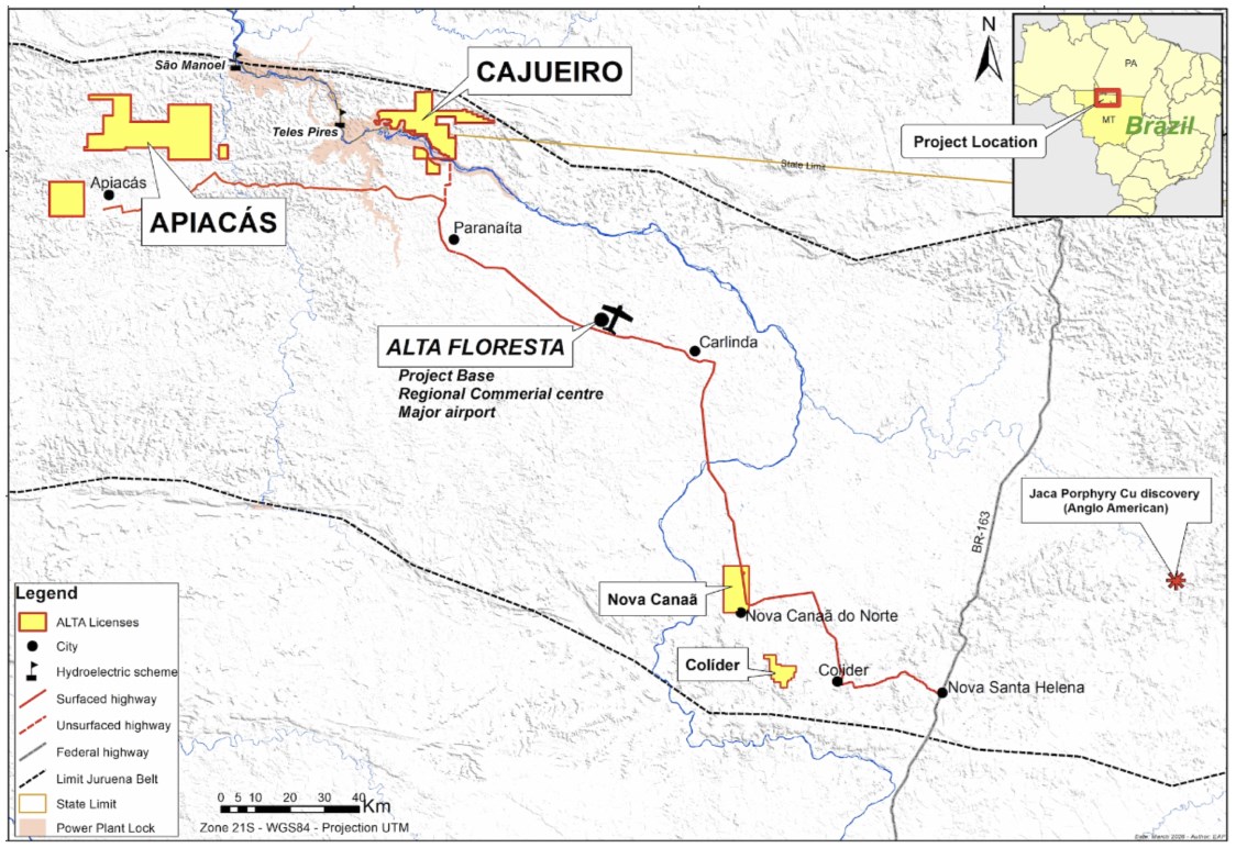
Figure 1: Location of Altamira Gold’s projects in the Alta Floresta Belt.
To view an enhanced version of this graphic, please visit:
https://images.newsfilecorp.
The Cajueiro district consists of two independently estimated gold mineral resources at Cajueiro Central and Maria Bonita, plus a series of eight additional untested exploration targets within a radius of 8km of Cajueiro Central.
The Cajueiro Central area has a current open pit resource1 of 5.66Mt @ 1.02 g/t gold containing 185,000 oz in the Indicated Resource category and 12.66Mt @ 1.26 g/t gold (515,000 oz) in the Inferred Resource category (estimated using a cut-off grade of 0.25g/t Au and a gold price of US$1,500/oz).
The Maria Bonita open-pit resource consists of Indicated Resources of 24.19Mt @ 0.46g/t gold (357,800oz) and Inferred Resources of 25.64Mt @ 0.44g/t gold (362,400oz)2. These resources were calculated using a 0.2 g/t gold cut-off grade and a gold price of US$2,780/oz. These resources include near-surface saprolite Indicated Resources of 2.02Mt @ 0.59g/t gold (38,000oz) and Inferred Resources of 0.68Mt @ 0.40g/t gold (8,700oz).
The Maria Bonita porphyry gold deposit forms part of a district-scale portfolio of prospects that are interpreted as having a similar geological origin (Figure 2). The Cajueiro area is characterized by a 15km stretch of former alluvial gold workings along the Teles Pires river. The source of some of this alluvial gold is related to a pronounced east-west corridor of gold anomalies in soils and rock chips and a set of sub-cropping intrusions extending east-west over 8km, implying the presence of a long-standing and deep-seated reactivated crustal structure.
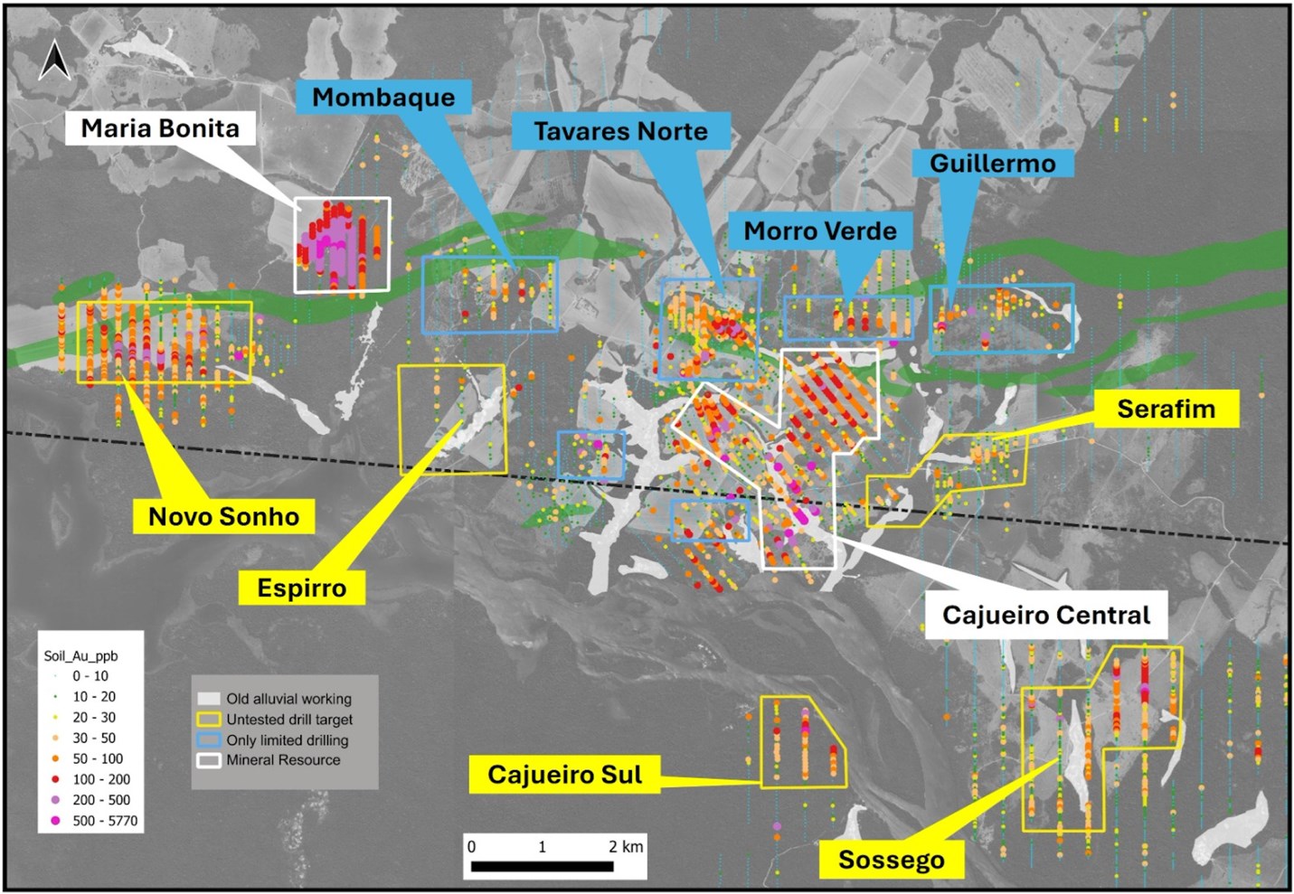
Figure 2: Cajueiro district mineral resources at Cajueiro Central and Maria Bonita (white labels) and prospects (blue labels with scout drilling, yellow labels not yet drilled). An alignment of six of the targets occur in close spatial association to a pronounced east-west fault corridor marked by later gabbroic dykes.
To view an enhanced version of this graphic, please visit:
https://images.newsfilecorp.
Maria Bonita Drilling Update
MBA038 and MBA039, the third and fourth drill holes in our follow up drilling program aimed at extending the Maria Bonita mineral resource to the west, confirm that Maria Bonita extends beyond the limits of the existing NI 43-101mineral resource and optimised pit (Figure 3). Drilling is ongoing.
In the northern part of the area recently drill tested, volcanic tuffs form the majority of the country rock. These tuffs are hydrothermally altered and are the hosts to local quartz veins and stockworks. These exo-intrusive vein zones, together with the early phases of the porphyry complex, represent the principal gold targets. The later porphyry pulses and the volcanic tuff wall rock, without hydrothermal veining, do not contain significant gold.
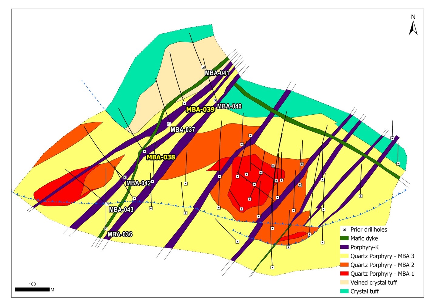
Figure 3: Location of drill holes MBA038 and MBA039.
To view an enhanced version of this graphic, please visit:
https://images.newsfilecorp.
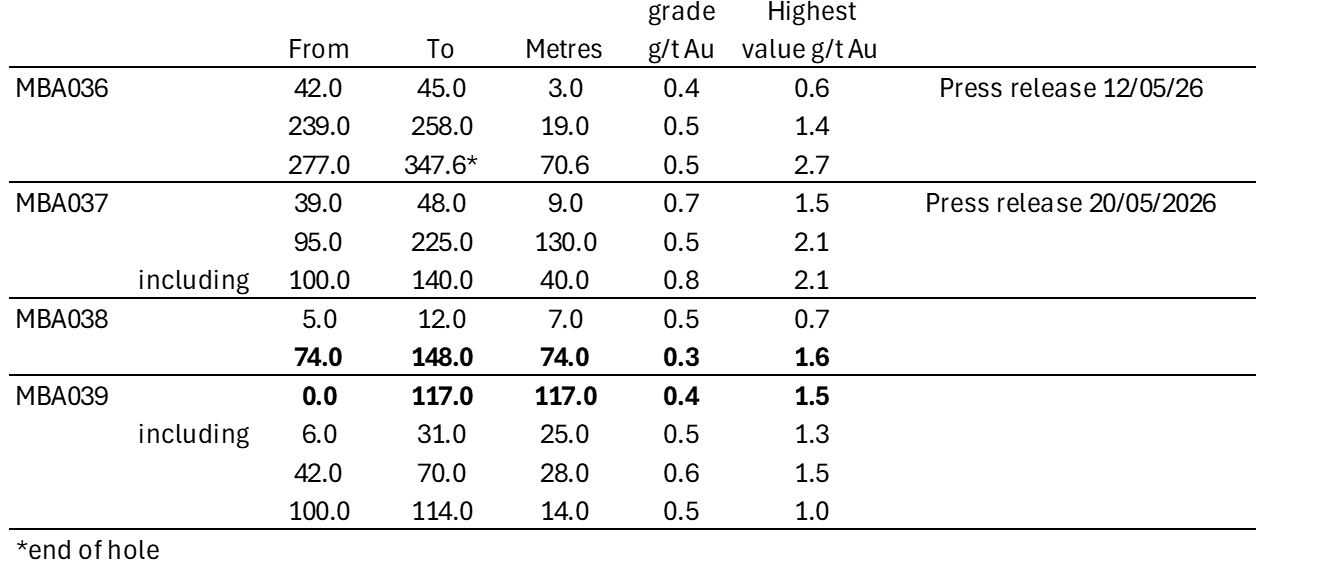
Table 1: Summary of results from drill holes MBA038 and MBA039 (including prior released results for MBA036 and MBA037).
To view an enhanced version of this graphic, please visit:
https://images.newsfilecorp.
Core logging indicates that gold distribution within the intervals outlined in Table 1 for all holes is generally related to the frequency of hydrothermal quartz veining. Vein densities of 2-4 veinlets per metre of core are common within the porphyry and up to 8 veins per metre in discrete sections of the wall rock tuffs. Quartz veins range from millimetric to 70 mm in true thickness.
Unlike the main early porphyry at Maria Bonita, the western early porphyry intercepts contain pyrite (up to 1% by volume) plus magnetite. Alteration is mainly potassic in character, similar to the Maria Bonita early porphyry. Sulphide content appears to increase westwards which may signal an opportunity to map the mineralization through IP chargeability surveys. The main Maria Bonita porphyry shows a resistivity anomaly but no discernible chargeability due to its very low sulphide content.
Gold grades within the mineralized sections of the porphyry have bulk grades around 0.5g/t Au with peak values of 1-2g/t Au (i.e. the intervals are consistently mineralized with no apparent nugget effect). In the sections of drill holes MBA038 and 039 comprising later phases of porphyry, gold values are low, indicating waning mineralization as the hydrothermal system evolved.
In the adjoining wall rock tuffs (MBA038), quartz veining is found in discrete zones with higher average gold values than those in the porphyry. The 74m interval from 74m downhole is mineralized throughout, with a peak one-metre sample value of 1.64g/t Au. The notable higher values in the veined tuff zones at 110m and 130m may point to a potential earlier and better mineralized phase of porphyry located nearby but off-hole (Figure 4).
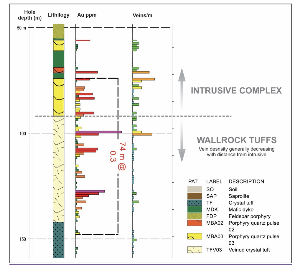
Figure 4: Schematic section of MBA038 showing gold values and quartz vein frequency spanning the porphyry and tuff wall rock contact.
To view an enhanced version of this graphic, please visit:
https://images.newsfilecorp.
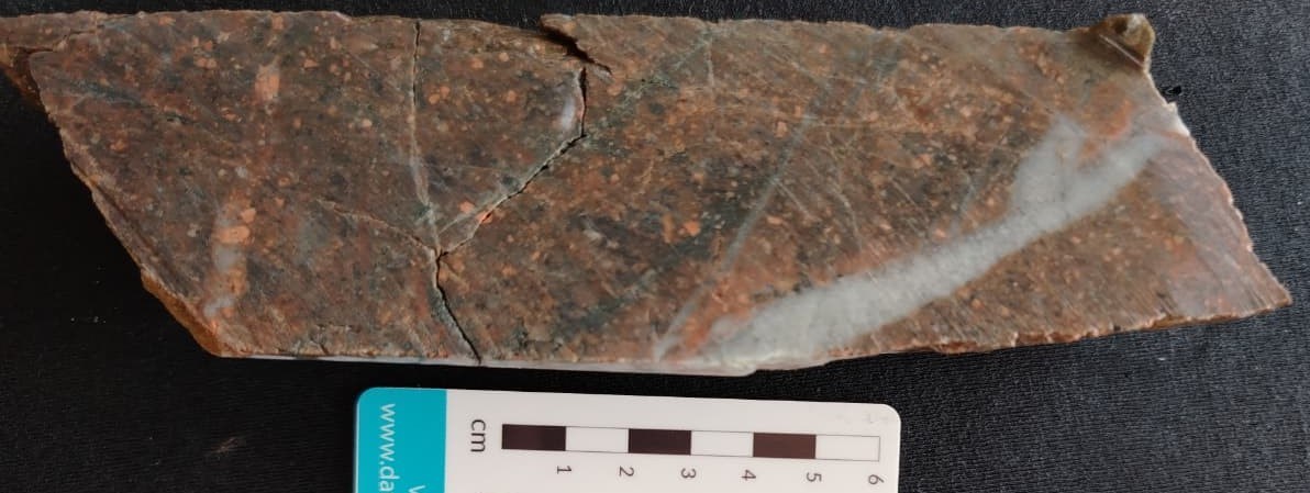
Figure 5: Typical ‘A’ type quartz veining in crystal tuffs in MBA039 at 110m depth. Assay interval 1m @ 0.9g/t gold.
To view an enhanced version of this graphic, please visit:
https://images.newsfilecorp.
Mombaque Prospect Drilling Update
Two scout drill holes completed at the Mombaque prospect targeted a gold in soil anomaly occurring in brecciated tuffs above an inferred magnetic intrusive body. This is a similar geological setting to that being tested in the western extensions of Maria Bonita (as reported above).
The target lies between magnetic and radiometric features mapped as younger syenogranites and large-scale regional gabbro dykes (Figure 6). The objective of the scout drilling was to test both the soil anomaly (MBQ001) and the underlying magnetic source (MBQ002).
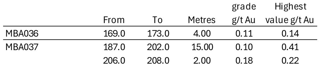
Table 2: Summary of results from drill holes MBQ001 and MBA002
To view an enhanced version of this graphic, please visit:
https://images.newsfilecorp.
Drill results (Figures 6 & 7 and Table 2) show only narrow zones of low-grade gold in tuffs and intrusives. The magnetic felsic intrusive intersected in the lower part of hole MBQ002 which is inferred to be the source of the magnetic anomaly does not contain significant gold in the area drill tested.
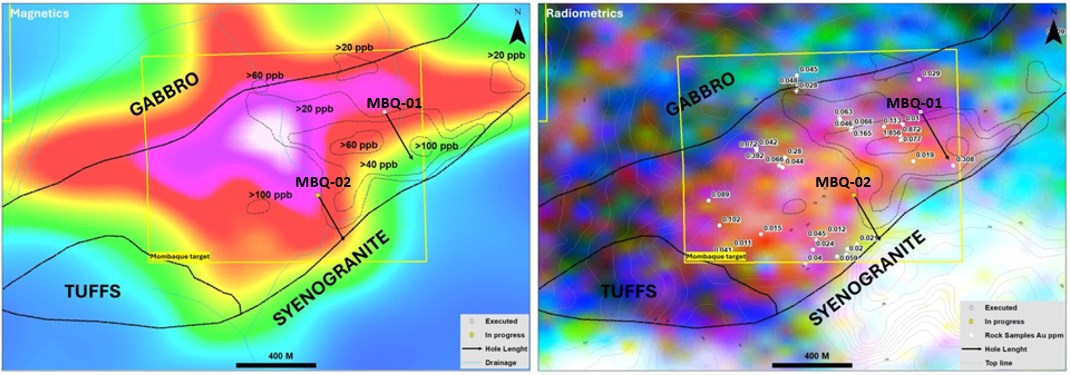
Figure 6: Location of Mombaque drill holes with respect to soil and rock chip anomalies, modelled magnetic source and radiometric response.
To view an enhanced version of this graphic, please visit:
https://images.newsfilecorp.
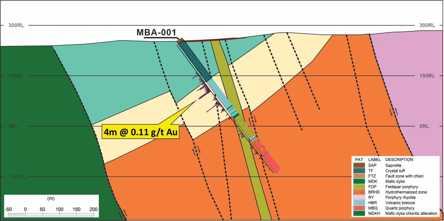
Figure 7: Schematic drill section of hole MBQ001 showing the intersection of gold associated with brecciation in a felsic intrusive overlain by tuffs.
To view an enhanced version of this graphic, please visit:
https://images.newsfilecorp.
The 750m long soil anomaly at Mombaque is not fully explained by the drill results. There remains the possibility that a fertile intrusive subcrops in the area and is obscured by tuff cover. The two drill holes are located 500m apart. However, the current drill results reduce the likelihood of a scalable mineralized system at this target.
In the short term, the Company plans to continue the drill testing of the western extensions of the Maria Bonita porphyry system to trace the prospective intrusions and their contacts with the wall rock tuffs so as to provide the basis for a mineral resource update.
Qualified Person
Fernando Benegas, FAusIMM, a consultant to the Company as well as a Qualified Person as defined by National Instrument 43-101, supervised and approved the preparation of the technical information in this news release.
About Altamira Gold Corp.
The Company is focused on the exploration and development of gold projects within western central Brazil, strategically advancing four projects spanning over 900,000 hectares within the prolific Juruena Gold Belt-an area that has historically yielded over 6 million ounces of placer gold3. The Company’s advanced Cajueiro project contains two gold deposits. Ongoing exploration and fieldwork at Cajueiro indicate the presence of multiple hard rock gold occurrences, traceable from historical alluvial gold production, highlighting the region’s exceptional gold endowment and potential scalability. With two independently established mineral resources, a highly prospective geological setting and a track record of significant discoveries, the Company is well-positioned to unlock further value across its extensive land package.
1NI 43-101 Technical Report, Cajueiro Project, Mineral Resource Estimate: Global Resource Engineering, Denver Colorado USA, 10thOctober 2019; Authors K. Gunesch, PE; H. Samari, QP-MMSA; T. Harvey, QP-MMSA
2 NI43-101 Technical Report, Mineral Resource for the Maria Bonita Prospect: VMG Consultoria, Belo Horizonte, Minas Gerais, Brazil. 12th June 2025; Author V. Myadzel
3 Juliani, C. et al; Gold in Paleoproterozoic (2.1 to 1.77 Ga) Continental Magmatic Arcs at the Tapajós and Juruena Mineral Provinces (Amazonian Craton, Brazil): A New Frontier for the Exploration of Epithermal-Porphyry and Related Deposits. Minerals 2021, 11, 714. https://doi.org/10.3390/
On Behalf of the Board of Directors,
ALTAMIRA GOLD CORP.
“Michael Bennett”
Michael Bennett
President & CEO
Tel: 604.676.5661
Toll-Free:1-833-606-6271
[email protected]
www.altamiragold.com
Neither TSX Venture Exchange nor its Regulation Services Provider (as that term is defined in policies of the TSX Venture Exchange) accepts responsibility for the adequacy or accuracy of this release.
The securities described herein have not been registered under the U.S. Securities Act or any state securities laws and may not be offered or sold in the United States absent registration or an applicable exemption from registration requirements under the U.S. Securities Act and any applicable state securities laws.
Forward-Looking Statements
Certain information contained herein constitutes “forward-looking information” under Canadian securities legislation. Forward-looking information includes, but is not limited to, statements with respect to the extension of the Warrants. Generally, forward-looking information can be identified by the use of forward-looking terminology such as “will”, “intends” or variations of such words and phrases or statements that certain actions, events or results “will” occur. Forward-looking statements are based on the opinions and estimates of management as of the date such statements are made and they are subject to known and unknown risks, uncertainties and other factors that may cause the actual results to be materially different from those expressed or implied by such forward-looking statements or forward-looking information, including the receipt of all necessary regulatory approvals. Although management of the Company has attempted to identify important factors that could cause actual results to differ materially from those contained in forward-looking statements or forward-looking information, there may be other factors that cause results not to be as anticipated, estimated or intended. There can be no assurance that such statements will prove to be accurate, as actual results and future events could differ materially from those anticipated in such statements. Accordingly, readers should not place undue reliance on forward-looking statements and forward-looking information. The Company will not update any forward-looking statements or forward-looking information that is incorporated by reference herein, except as required by applicable securities laws.
Quality Assurance/Quality Control
Drill holes commence in HQ diameter (63.5mm) and proceed to the base of weathering where core diameter is reduced to NQ (47.6mm). Logging and sampling are completed at a secure Company facility located on site. Drill core is cut in half on site by a saw cut or slicer (in soft saprolite).
Until dispatch, samples are stored under the supervision the Company’s exploration office. The samples are couriered to the assay laboratory using a commercial contractor. Pulps are returned to the Company and archived.
For all drilling, half core is submitted to SGS Geosol, a leading commercial laboratory in Brazil and analysed for gold by 50g fire assay, plus a suite of other elements by the ICP atomic absorption method, using standard laboratory procedures. Soil and rock chip samples follow the same analytical protocol.
Quality control of drill hole assays follows normal industry procedures of inserting control samples randomly into the submitted batch, comprising field duplicates, independent reference samples and “blank” samples. Selected batches of sample pulps are periodically resubmitted to a third-party laboratory to check the main laboratory precision and accuracy.
Drill holes results are quoted as down-hole length weighted intersections.
Additional information regarding the Company data verification processes is set out in the NI 43-101 Technical Report, Maria Bonita Prospect, June 2025, which can be found on the Company’s website.

To view the source version of this press release, please visit https://www.newsfilecorp.com/