


Timberline (TBR.V): Identifies Large IP-Resistivity Anomaly at the Eureka Gold Project, Nevada
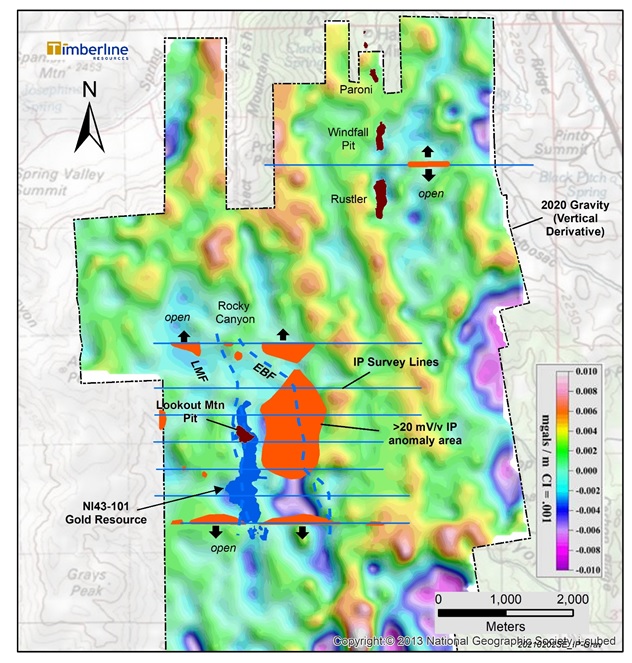
COEUR D’ALENE, ID / ACCESSWIRE / February 3, 2021 / Timberline Resources Corporation (OTCQB:TLRS)(TSXV:TBR) (“Timberline” or the “Company”) today announced results of an Induced Polarization – Resistivity (IP) geophysical survey (Figure 1) at its 100%-controlled Eureka Project in Nevada. The IP survey included 28.4 line-kilometres over eight lines, focused primarily at the Lookout Mountain Target. IP can be an effective tool for mapping subsurface electrical characteristics of the rocks related to the distribution of sulfide minerals and organic carbon, which are often associated with Carlin-type gold deposits. IP surveys may also help map fault structures that are related to or crosscut mineralization.
Some key highlights of the IP survey at Eureka include:
- A strong chargeability anomaly spanning at least two kilometres in a north-south direction east of the Lookout Mountain gold resource and east of the Rocky Canyon Zone (Figure 1);
- Identified two major fault zones: the Lookout Mountain Fault (LMF) which is associated with known gold mineralization, and the East Bounding Fault (EBF) which is undrilled; and
- A moderate chargeability anomaly occurs on the test line at the Windfall Target and has a similar morphology and relationship to known gold mineralization as at the Lookout Zone.
Timberline also previously reported a district-scale gravity survey at Eureka (see Company news release dated Nov 2, 2020 at http://timberlineresources.co/press-releases). These two large-scale geophysical surveys are complementary, and the Timberline technical team is working towards a fully integrated interpretation of these data with the growing geological database, mapping, and modeling.
Patrick Highsmith, Timberline’s President and CEO commented, “The 2020 IP survey at the Eureka Project suggests a much larger footprint to the mineral system than is evident from drilling to date. Our integrated interpretation of the IP and gravity surveys in concert with our improved understanding of the geology has highlighted many new targets at Eureka. Our initial focus in 2021 will be to link the recently announced high-grade step-out drill intercepts with the main body of the Lookout Mountain resource.”
IP Survey Details and Discussion
Simcoe Geoscience Ltd. of Toronto, Ontario (“Simcoe”) completed the time-domain IP survey using the dipole-dipole method along eight lines totalling 28.4 line kilometres (Figure 1), generally spaced 400 metres apart. The survey configuration (200-metre dipole separation) resulted in an estimated depth of resolution of more than 600 metres. The majority of the survey was conducted at the Lookout Mountain Target, where it was designed to cover the main body of known gold mineralization and extend eastward across a graben structure.
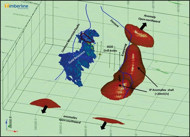
The IP data was processed by Simcoe with an independent review by Wright Geophysics. The geophysicists prepared a 2D inversion of the data on each line to produce cross-sections of resistivity and chargeability contours. The 2D cross-sections are integrated into 3D models representing the chargeability and resistivity data. A 3D perspective view of the chargeability model and Lookout Mountain block model shows an intense chargeability anomaly (≥20 mV/v) at depth and approximately 500 metres east of the known gold resource (Figure 2).
Figure 1. Eureka Project IP Survey and Anomalies over Gravity Vertical Derivative Base Map
To see an enhanced view of image, click link: https://timberlineresources.co/wp-content/uploads/2021/02/PR355Fig1_Cropped-scaled.jpg
The model shows that the newly defined IP anomaly is associated with a major fault (EBF) and has a complex shape. There is a saddle between two lobes that rise closer to surface, the northern of which comes to within approximately 150 metres of surface. There is also a separate anomaly farther north in the Rocky Canyon area. The 2020 core holes were drilled to the west of and in the saddle of the main IP feature and terminated above the interpreted depth of the strongest part of the anomaly. The known gold mineralization at Lookout Mountain and the higher-grade Water Well Zone is associated with the lower magnitude part of the IP response.
Figure 2. 3D View of Lookout Mountain Gold Resource and IP Anomalies with 2020 Drillholes
To see an enhanced view of image, click link: https://timberlineresources.co/wp-content/uploads/2021/02/PR355Fig2-scaled.jpg
Historic gold mining at Windfall recovered approximately 115,000 ounces of gold from altered shale and dolomite along a major fault, a similar stratigraphic and structural setting as at Lookout Mountain. The sedimentary rocks dip east from the historic pits. Drilling by Timberline and others has intercepted relatively high-grade gold (> 3 g/t) between and beneath the pits, as well as along trend to the north and east.
The Company completed a single east-west IP test line between the Windfall and Rustler historic open pits (Figure 1). As at Lookout Mountain, a distinct chargeability anomaly occurs east of the known mineralization (Figure 3). The shape of the geophysical anomalies supports an eastward dip to the favorable rock sequence. The geophysics also suggests the presence of several faults in the Windfall area. The single line survey at the Windfall area identifies a need for a more extensive survey, and the team is planning follow-up geophysics for 2021.
Figure 3. Windfall Target 3D Perspective with 2D IP Inversion Section

To see an enhanced view of image, click link: https://timberlineresources.co/wp-content/uploads/2021/02/PR355Fig3-scaled.jpg
Steven Osterberg, Ph.D., P.G., Timberline’s Vice President Exploration, is a Qualified Person as defined by National Instrument 43-101 and has reviewed and approved the technical contents of this release. Dr. Osterberg is not independent of the Company as he is an officer and a director.